Home > Europe > United Kingdom > England > Norfolk > Caister on Sea
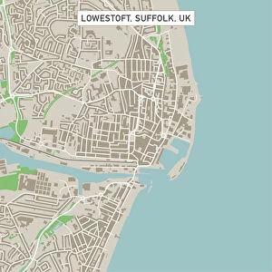
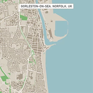
Caister-on-Sea Norfolk UK City Street Map

![]()
Wall Art and Photo Gifts from Fine Art Storehouse
Caister-on-Sea Norfolk UK City Street Map
Vector Illustration of a City Street Map of Caister-on-Sea, Norfolk, UK. Included files are EPS (v10) and Hi-Res JPG.
Data courtesy from Ordnance Survey: VectorMap District
https:/ordnancesurvey.co.uk/business-and-government/products/vectormap-district.html
OS OpenData is free to use under the Open Government Licence (OGL).
Contains OS data eCrown copyright and database right 2017.
http:/nationalarchives.gov.uk/doc/open-government-licence/version/3/
Unleash your creativity and transform your space into a visual masterpiece!
Frank Ramspott
Media ID 15055269
© Frank Ramspott, all rights reserved
Aerial View Computer Graphic Directly Above Gray Green Norfolk North Sea Road Map Street Map Text Caister On Sea Digitally Generated Image
FEATURES IN THESE COLLECTIONS
> Aerial Photography
> Related Images
> Arts
> Contemporary art
> Digital artwork
> Street art
> Arts
> Portraits
> Pop art gallery
> Street art portraits
> Arts
> Street art graffiti
> Digital art
> Digital paintings
> Arts
> Street art graffiti
> Digital art
> Vector illustrations
> Europe
> United Kingdom
> England
> Norfolk
> Caister-on-Sea
> Europe
> United Kingdom
> England
> Norfolk
> Caister on Sea
> Europe
> United Kingdom
> England
> Norfolk
> North Green
> Europe
> United Kingdom
> England
> Norfolk
> Related Images
> Europe
> United Kingdom
> Maps
> Fine Art Storehouse
> Map
> Street Maps
EDITORS COMMENTS
This print showcases a beautifully detailed vector illustration of the city street map of Caister-on-Sea, Norfolk, UK. The image captures the essence of this coastal town with its intricate road network and charming buildings. Created using EPS (v10) and Hi-Res JPG files, this artwork is a testament to the artistry of cartography. The data used to create this stunning piece comes courtesy of Ordnance Survey: VectorMap District, ensuring accuracy and reliability. It's worth noting that OS OpenData is freely available for use under the Open Government Licence (OGL), making it accessible to all. The photograph offers an aerial view directly above Caister-on-Sea, allowing viewers to appreciate its physical geography in vibrant colors. The combination of gray streets, green spaces, blue coastline, and white buildings creates a visually striking composition. With no people present in the image, the focus remains solely on the intricacies of this digitally generated map design. This print would make an excellent addition to any home or office space for those who appreciate both art and geography. Frank Ramspott has skillfully captured Caister-on-Sea's unique charm through his artistic lens while paying homage to its rich history and culture.
MADE IN THE USA
Safe Shipping with 30 Day Money Back Guarantee
FREE PERSONALISATION*
We are proud to offer a range of customisation features including Personalised Captions, Color Filters and Picture Zoom Tools
SECURE PAYMENTS
We happily accept a wide range of payment options so you can pay for the things you need in the way that is most convenient for you
* Options may vary by product and licensing agreement. Zoomed Pictures can be adjusted in the Cart.