Home > Maps and Charts > Related Images
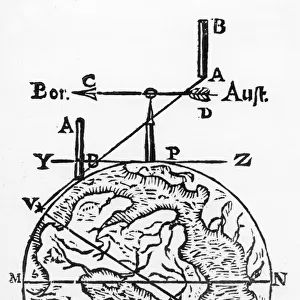
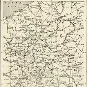
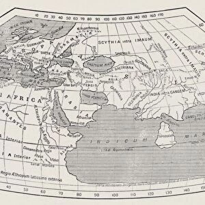
Map showing the supposed location of Paradise

![]()
Wall Art and Photo Gifts from Heritage Images
Map showing the supposed location of Paradise
Map showing the supposed location of Paradise. The Garden of Eden is represented by the blue-tinted quadrant. After an engraving of 1678 from a work by Johann Herbinius (1633-1676), a Silesian-born Lutheran minister
Heritage Images features heritage image collections
Media ID 14863872
© Oxford Science Archive / Heritage-Images
Cartography Garden Of Eden Jewish Johann Judaism Map Making Oxford Science Archive Paradise
EDITORS COMMENTS
This print showcases a remarkable map that unveils the supposed location of Paradise, with the Garden of Eden depicted in a mesmerizing blue-tinted quadrant. Created by Johann Herbinius, a gifted Silesian-born Lutheran minister, this engraving from 1678 offers an intriguing glimpse into biblical cartography. As we delve into this intricate artwork, we are transported back to the seventeenth century when religious beliefs and exploration intertwined. With meticulous detail and vibrant colors, Herbinius skillfully brings to life the sacred grounds described in Christianity and Judaism. The map serves as a testament to humanity's eternal fascination with locating the mythical Garden of Eden—a place shrouded in mystery and symbolism. It invites us to ponder questions about our origins and spiritual connection with nature. Herbinius' creation not only reflects his artistic prowess but also highlights his deep understanding of religious texts. This print is more than just an aesthetically pleasing piece; it represents centuries-old interpretations of scripture and acts as a visual guide for believers seeking enlightenment. Preserved within Oxford Science Archive, this historical gem continues to captivate viewers today. Its presence reminds us that maps hold immense power—they can transport us through time while unraveling ancient mysteries. Let this extraordinary print inspire you to embark on your own quest for knowledge and uncover hidden truths within its intricate lines and vivid hues.
MADE IN THE USA
Safe Shipping with 30 Day Money Back Guarantee
FREE PERSONALISATION*
We are proud to offer a range of customisation features including Personalised Captions, Color Filters and Picture Zoom Tools
SECURE PAYMENTS
We happily accept a wide range of payment options so you can pay for the things you need in the way that is most convenient for you
* Options may vary by product and licensing agreement. Zoomed Pictures can be adjusted in the Cart.