Home > Animals > Mammals > Muridae > Western Mouse
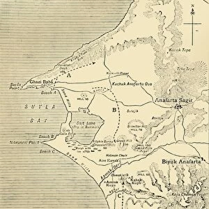
Map of the Western Front at the beginning of the Allied offensive on the Somme, France, World War I, July 1916 (litho)
")
![]()
Wall Art and Photo Gifts from Fine Art Finder
Map of the Western Front at the beginning of the Allied offensive on the Somme, France, World War I, July 1916 (litho)
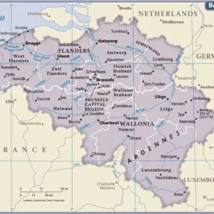
7172515 Map of the Western Front at the beginning of the Allied offensive on the Somme, France, World War I, July 1916 (litho) by English School, (20th century); Private Collection; (add.info.: Map of the Western Front at the beginning of the Allied offensive on the Somme, France, World War I, July 1916. Illustration from The Illustrated War Record of the Most Notable Episodes of the Great European War (Headley Bros, Ltd, London, c1917).); © Look and Learn
Media ID 24736228
© Look and Learn / Bridgeman Images
Batlefield Battlefiled City Map City Plan Flanders General Map Site Of Battle Street Plan 1914 1918 Wwi Ww One Belgians Belgium Belgian Benelux Countries First World War 1914 1918 War Zone
FEATURES IN THESE COLLECTIONS
> Animals
> Mammals
> Muridae
> Western Mouse
> Arts
> Portraits
> Pop art gallery
> Street art portraits
> Europe
> Belgium
> Related Images
> Europe
> France
> Canton
> Somme
> Europe
> United Kingdom
> Maps
> Fine Art Finder
> Artists
> Bernard (after) Partridge
> Fine Art Finder
> Artists
> English School
EDITORS COMMENTS
This lithograph print showcases a detailed map of the Western Front at the onset of the Allied offensive on the Somme in France during World War I. Created in July 1916, this historical artifact provides a visual representation of the strategic landscape that shaped one of the most significant battles in history. The map, part of The Illustrated War Record of the Most Notable Episodes of the Great European War, offers an invaluable glimpse into this tumultuous period. It highlights key locations and battlefields across Flanders in Belgium and northern Germany, illustrating their significance within the broader context of European geopolitics. As we examine this intricate depiction, we are transported back to a time when nations clashed and alliances were tested. We see France and its overseas territories standing alongside Great Britain as they confront Germany's forces. The British Isles emerge as a crucial stronghold for these allied powers, while Belgium plays a pivotal role as well. Through this historic map, we gain insight into not only geographical boundaries but also into moments that forever altered world history. It serves as a reminder of sacrifice and valor exhibited by soldiers who fought bravely on these very grounds. Preserved within private collections today, this litho print from Fine Art Finder allows us to appreciate both its artistic value and its profound historical significance. As we delve into its intricacies, let us honor those who lived through these turbulent times and remember their enduring legacy.
MADE IN THE USA
Safe Shipping with 30 Day Money Back Guarantee
FREE PERSONALISATION*
We are proud to offer a range of customisation features including Personalised Captions, Color Filters and Picture Zoom Tools
SECURE PAYMENTS
We happily accept a wide range of payment options so you can pay for the things you need in the way that is most convenient for you
* Options may vary by product and licensing agreement. Zoomed Pictures can be adjusted in the Cart.