Home > Maps and Charts > Africa
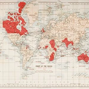
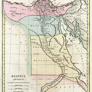
Partial Map Of Middle East Showing Red Sea, Persian Gulf Horn Of Africa Gulf Of Aden In 1890S From The Citizens Atlas Of The World Published London Circa 1899

![]()
Wall Art and Photo Gifts from Design Pics
Partial Map Of Middle East Showing Red Sea, Persian Gulf Horn Of Africa Gulf Of Aden In 1890S From The Citizens Atlas Of The World Published London Circa 1899
Design Pics offers Distinctively Different Imagery representing over 1,500 contributors
Media ID 18189835
© Ken Welsh / Design Pics
Africa Atlas Gulf Horn Middle East Persian Aden Nineteenth
FEATURES IN THESE COLLECTIONS
> Maps and Charts
> Related Images
> Maps and Charts
> World
EDITORS COMMENTS
This print takes us back to the late 19th century, offering a glimpse into the geopolitical landscape of the Middle East. The "Partial Map Of Middle East Showing Red Sea, Persian Gulf Horn Of Africa Gulf Of Aden In 1890S" is a remarkable piece from "The Citizens Atlas Of The World" which was published in London around 1899. With its vibrant colors and intricate details, this vertical map transports us to an era when cartography was both an art form and a scientific endeavor. It showcases the Red Sea, Persian Gulf, Horn of Africa, and Gulf of Aden with utmost precision and accuracy for its time. As we study this historical artifact closely, we can appreciate how it captures not only geographical boundaries but also political dynamics that shaped the region during the 19th century. This map serves as a valuable resource for historians and enthusiasts alike who seek to understand the complexities of this pivotal period in history. Ken Welsh's expertly preserved print allows us to connect with our past by providing a window into how people perceived and navigated their world over a hundred years ago. Whether displayed in homes or educational institutions, this stunning image invites viewers on an enlightening journey through time while reminding us of humanity's enduring fascination with maps as tools for exploration and understanding.
MADE IN THE USA
Safe Shipping with 30 Day Money Back Guarantee
FREE PERSONALISATION*
We are proud to offer a range of customisation features including Personalised Captions, Color Filters and Picture Zoom Tools
SECURE PAYMENTS
We happily accept a wide range of payment options so you can pay for the things you need in the way that is most convenient for you
* Options may vary by product and licensing agreement. Zoomed Pictures can be adjusted in the Cart.